Anyone who regularly swims in the Baltic Sea knows the phenomenon: When the wind blows from the land towards the sea, use caution when diving into the water, even in midsummer. While the water may have been comfortably warm at 22°C the day before, it may suddenly cool down to well below 20°. This phenomenon is the result of a process oceanographers call “upwelling”. The wind pushes the warm surface waters towards the open sea, and colder water from the depths rises to the surface – which swimmers notice immediately. However, the upwelling also has positive effects: Especially in summer, the warmer and lighter surface layers often lack the nutrients to sustain plant life, causing the marine plants to die. The upwelling replenishes nutrients from the depths to the sun-flooded upper water layers which support the growth of plants, and other marine animals benefit accordingly.
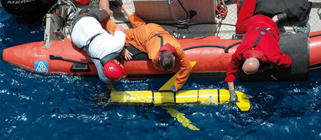
This principle works in the oceans, but it also works on a smaller scale in a shallow marginal sea like the Baltic Sea. However, in contrast to oceanic upwelling off Africa or South America, special techniques are necessary in order to accurately measure the small-scale and rapidly occurring processes. Oceanographers at GEOMAR Helmholtz Centre for Ocean Research Kiel have now presented the results of an experiment with so-called “gliders” in the Bay of Eckernförde in July 2010 in the international journal “Biogeosciences”. “Gliders are robots that operate remotely over days, weeks and months to collect data and send it via satellite to the home institutions,” said Dr. Johannes Karstensen, lead author of the study. Although the glider technology is already a proven tool for Kiel researchers, the application in the Bay of Eckernförde was a truly novel approach: “It was the first glider mission in the shallow Baltic Sea. Typically we work with the devices in the open ocean where they sail back and forth between the water surface and 1000 meters of water depth,” explains Dr. Karstensen.
The aim of the campaign was to investigate the effect of summertime coastal upwelling on the vertical distribution of temperature, salinity, oxygen, chlorophyll and turbidity in the water. The glider was adjusted so that it sailed every 15 minutes from the surface to about 20 meters depth and back to the surface. “The device had to be set very precisely, so it does not get stuck in the muddy seabed of the Baltic,” the oceanographer recalled. The area chosen by the researchers was near Boknis Eck where Kiel scientists have measured temperature, nutrient concentrations, algal blooms and oxygen content once a month for over 50 years.
During the week-long campaign, two upwelling events induced by rather moderate winds were recorded. In just a few hours, strong cooling of the warm surface water occurred, from 22°C down to below 16°C. Within hours of a weakening and direction change of the wind, the flow returned and warm surface layers were once again present. “The intensity and rapidity with which the events took place, was very surprising to us. Only the high temporal and spatial resolution of the data allowed us to analyze these enormous fluctuations exactly,” says Karstensen.
By combining the measurements in the water with GEOMAR’s wind measurements at Kiel lighthouse it was possible to reconstruct the strength of the upwelling in the Bay of Eckernförde all the way back to 1982. This information could then be used to interpret the obtained monthly ship data at the Boknis Eck measurement station.
Besides the scientific relevance of the campaign, the scientists were able to demonstrate that gliders can also be used as highly suitable observation platforms in the Baltic Sea.
Reference:
Karstensen, J., T. Liblik, J. Fischer, K. Bumke, G. Krahmann (2014): Summer upwelling at the Boknis Eck time-series station (1982 to 2012) – a combined glider and wind data analysis. Biogeosciences, 11, 3603-3617,
http://dx.doi.org/10.5194/bg-11-3603-2014
Links:
www.geomar.de GEOMAR Helmholtz Centre for Ocean Research Kiel
www.geomar.de/en/research/fb1/fb1-po/observing-systems/glider
Information about gliders on the GEOMAR webpages
www.bokniseck.de Boknis Eck Time Series Station
http://edition.cnn.com/video/?/video/international/2010/07/29/earths.frontiers.ocean.gliders.cnn CNN documenation about the glider campaign at Boknis Eck
Contact:
Dr. Johannes Karstensen (GEOMAR, RD1 – Physical Oceanography)
jkarstensen@geomar.de
Jan Steffen (GEOMAR, Communication & Media), Tel.: (+49) 0431 600-2811
jsteffen@geomar.de
…