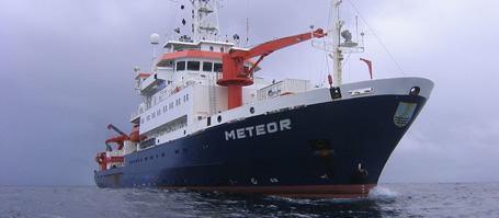
On the 28th of December 1908 the earth in Italy trembled. Shortly afterwards a Tsunami wave flooded the southern coast of Italy. Over 80,000 people died in the region around the seaport town Messina. However, the earthquake in Messina is only one of many examples of natural hazards occurring in this region regularly. According to estimations, around 10 percent of the tsunamis worldwide occur in the Mediterranean Sea. The continental margins of the Mediterranean Sea off the coast of southern Italy are situated along tectonic plates which are moving towards one another. This results in frequent volcanic eruptions and earthquakes. It is, however, still unclear whether the tsunami of 1908 was triggered by a sudden vertical movement along a major fault during the earthquake or was the result of a giant marine slide initiated by the earthquake. “To better understand the causes of those catastrophes we aim to examine the region thoroughly and collect data on seismic activities and the structure of the sediment in the area”, Prof. Dr. Sebastian Krastel from the Leibniz Institute of Marine Sciences (IFM-GEOMAR) outlines the goals of the expedition with the German research vessel METEOR. The expedition takes place in the region from late December 2011 till Mid January 2012. Prof. Dr. Krastel is also head of the research group “submarine hazards “of the Cluster of Excellence “The Future Ocean”.
During the expedition the scientists will be investigating the sea floor in three major regions: The Strait of Messina, the area off the coast of Sicily and the Gioia Basin. To do so the scientists are using a seismic-system developed by the IFM-GEOMAR. The system is able to create 3D graphical pictures of the layering of the sea floor. Additionally gravity corers will be used to obtain sediment cores. Using the collected data the main objectives will be to map and characterize volcanic and non-volcanic submarine slides and to identify fractured rocks, which are often accompanied by earthquakes. The work done by Prof. Dr. Krastel and his team is supported by Italian cooperation partners who for example have provided topographic information on the sea floor in this region. This information was decisive for the selection of the three research areas.
“The impression that natural hazards such as tsunamis are only occurring at the other end of the world is common. However there is a tremendous hazard potential in Europe about which we need to gain more knowledge. After all, 160 million people live along the Mediterranean Coast and every year 140 million people visit this area for their holidays”, the geoscientist from Kiel emphasizes.
Expedition at a glance:
FS Meteor expedition: M86/2
Chief scientist: Sebastian Krastel
Expedition period: 27.12.2011-17.01.2012
Starting harbour: Cartagena (Spain)
Research area: Strait of Messina, Coast of Sicily Final destination: Brindisi (Italy)
Links:
- Leibniz Institute of Marine Sciences (IFM-GEOMAR)
from January 1, 2012:
GEOMAR | Helmholtz Centre for Ocean Research Kiel - Cluster of Excellence „The Future Ocean“
Images:
Under www.ifm-geomar.de/presse images are available for download.
Contact:
Prof. Sebastian Krastel, Tel.: +49- 431- 600 2841,
skrastel@ifm-geomar.de
Jan Steffen (Public outreach), Tel.: +49- 431 - 600 2811,
jsteffen@ifm-geomar.de
…


