Scientists from Germany and New Zealand have now discovered surprisingly large gas hydrate and methane deposits while investigating the slopes on a multi-week expedition with the New Zealand research vessel RV TANGAROA.
Scientists from Kiel University, the Cluster of Excellence "The Future Ocean" and the GEOMAR Helmholtz Centre for Ocean Research Kiel travelled to the other end of the world about four weeks ago to investigate the causes of landslides off the east coast of New Zealand together with their New Zealand colleagues at the National Institute of Water and Atmospheric research (NIWA).
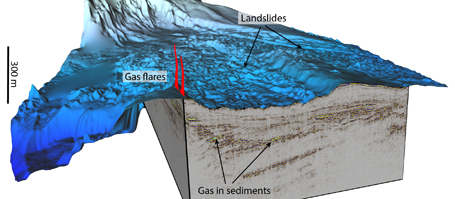
Until now, the causes of the slow movements of the large slopes are rather unknown. "However, we believe that such movements are very common and constitute an important process in the forming of continental margins," says Prof. Sebastian Krastel from the Cluster of Excellence "The Future Ocean". The latest marine technology is being used to investigate these processes, including the high-resolution 3D seismic system “P- Cable” from GEOMAR. It can depict the individual layers of the seabed in three dimensions and generate the respective data for research.
In use, this 3-D seismic created a surprising picture for the researchers. The scientists discovered clear signs of free gas in the sediment, as well as indications for large deposits of methane hydrate. The team identified a total of 99 natural gas leaks in an area of 50 square kilometers, from which gas bubbles rise up to 250 meters high in the water column. It is probably the densest concentration of gas openings on the ocean floor around New Zealand. "The gas field found differs greatly from resources previously known", says cruise leader Dr. Joshu Mountjoy from the NIWA in Wellington. "So far we have only observed such seeps in deeper water and in the context of plate tectonic processes." The new sites, however, are located in very shallow water and at the edge of the continental slope.
With the help of the new 3-D seismic, an accurate picture of the composition of individual layers of the sea floor could be drafted. "This technology is currently the best for representing gas distributions, so-called fluid systems in the sea floor," says Prof. Sebastian Krastel from the Institute of Geosciences at Kiel University and member of the Cluster of Excellence "The Future Ocean". "The area we investigated with the 3D seismic survey is one of the largest we have surveyed so far. The preliminary findings suggest we have collected optimal data material for researching the causes of landslides and the nature of instable slopes." These results are particularly interesting because methane hydrates dissolve when the temperature changes in the ocean and could thus destabilize continental slopes.
The expedition off the coast of New Zealand is part of the joint project SCHLIP (Submarine Clathrates Hydrate Landslide Imaging Project) between researchers of Kiel University, the GEOMAR Helmholtz Centre for Ocean Research Kiel, the University of Malta and the New Zealand partners NIWA (National Institute of Water and Atmospheric Research) and GNS Science in Lower Hutt, the University of Auckland as well as the Oregon State University (USA).
Background: P-Cable
The P-Cable system was developed to enable high-resolution 3-D images of the upper marine sediment layers from medium-sized research vessels. Unlike most commercial seismic systems, it is characterized by very low cost and the fact that it can even be used by small multi-purpose and research vessels. An enhanced version of the system, developed further at the GEOMAR Helmholtz Centre for Ocean Research Kiel, allows a particularly flexible adaptation to specific research questions and easy maintenance of the system, also at sea. Further information:
www.geomar.de/go/p-cable-system
Links
www.futureocean.org Der Exzellenzcluster „Ozean der Zukunft“
www.geomar.de Das GEOMAR Helmholtz-Zentrum für Ozeanforschung Kiel
www.ifg.uni-kiel.de Das Institut für Geowissenschaften der Christian-Albrechts-Universität zu Kiel
Images:
Images are available for download at www.geomar.de/n1920
Contact:
Professor Sebastian Krastel (Institute for Geosciences, Christian-Albrechts-Universität zu Kiel)
skrastel@geophysik.uni-kiel.de
Dr. Jörg Bialas (GEOMAR, FB4-Geodynamics)
jbialas@geomar.de
Friederike Balzereit (Communication & Media, Cluster of Excellence „The Future Ocean“), Tel.: (+49) 0431-880-3032
fbalzereit@uv.uni-kiel.de
Dr. Andreas Villwock (GEOMAR, Communication & Media), Tel.: (+49) 0431 600-2802
avillwock@geomar.de
…